Walking & packrafting in Lapland
No photos from this trip: the phone got drowned!
Concept
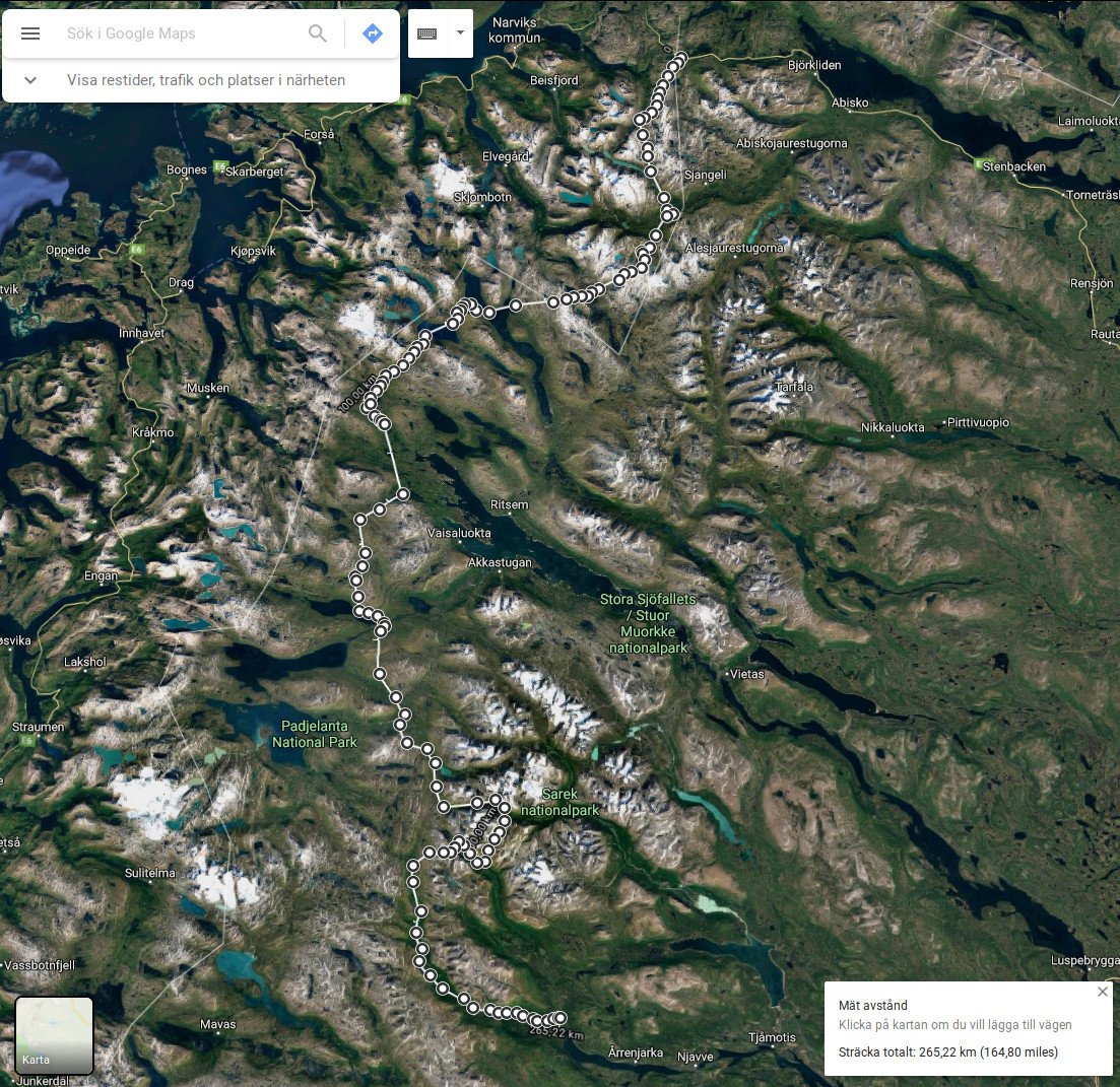
This trip was unusual in that I happened to receive my packraft by post earlier than expected and was then granted a longer-than-expected leave from parental duties. Thanks to this double stroke of good fortune, in a few days I was off to Lapland on a hastily improvised route, aiming to test the format of hiking with a light, inflatable packraft. With little time for planning, I chose the relatively familiar area between Kvikkjokk and Abisko in northern Sweden. The idea was to avoid touristed paths like Kungsleden and to take advantage of the freedom offered by the packraft, crossing awkwardly located lakes and paddling down the streams that flowed in the right direction. But the main objective was really to learn how to do solo packrafting trips. I was also curious to see how the packraft would hold its own in white water.
This concept worked well - on a conceptual level. But as for details, well... There were a lot of technical failures and silly mistakes on my part, culminating in the loss of most navigational equipment after capsizing in the rapids on day 4. The mild weather and my one surviving paper map made it possible for me to complete the journey as planned, and the trip turned out well in the end. But no photos - at fathom five my smartphone lies...
When
31 July - 10 August, 10 days of walking / paddling
Where
Along Norwegian-Swedish border between Riksgränsen (near Narwik) and Kvikkjokk via Padjelanta and Sarek national parks (~265 km by google maps). Trail: a well-trodden (but by no means crowded) trail goes west of the fiendishly overused Kungsleden, on the Norwegian side - from Sördalen just west of Riksgränsen all the way to Sitasjaure in the south (just north of Ritsem). To continue south without joining Kundsleden, one possibility is to veer to the west and follow Nordkalottleden along the border, although having a boat opens up more direct alternative routes. Having skirted or crossed the enormous Akkajaure near Ritsem, you have the choice between Padjelanta (flatter, good trails) and Sarek (steeper, bad trails) - I tried a bit of both.
Weather
Elevation 300-1300 m. Temperature about 5-15°C, often sunny, little wind. Some fog and rain the last few days.
Equipment
9 kg base weight + 8 kg of food and fuel.
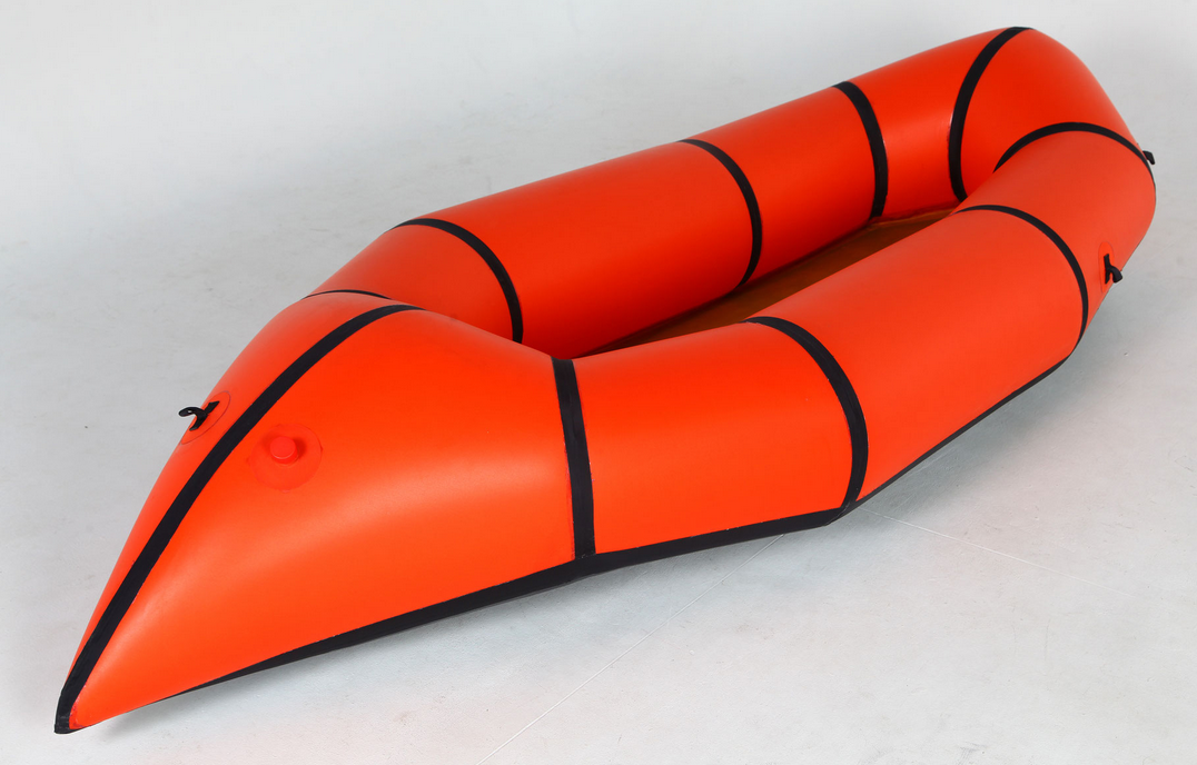
Packraft "Sinitsa" (3 kg with spraydeck, made in Russia).
For more details on the equipment and food used on this trip, see spreadsheet.html
Logistics
There: train to Riksgränsen (a few stops beyond Abisko, just before the Norwegian border). Back: bus from Kvikkjokk to Murjek, then train. No reservation is needed for the busses (credit cards are accepted on board), but smaller train stations do not have any ticket vending machines OR staff, so tickets have to be booked in advance or bought online.
Maps
Paper map: BD10 Sareks nationalpark Fjällkartan - 1:100 000. Maps on the phone (via Oruxmaps): google terrain with manually added waypoints (terrible quality - not recommended!). Online topographic maps are excellent but (annoyingly) separate for the Swedish and Norwegian sides of the border.
Days 0-2: Riksgränsen - Sitasjaure
Riksgränsen is a tiny train station next to a ski resort. There was actually a bit of snow left on some slopes even in late July. Eager to stretch my legs after a 24h+ train journey, I climbed right up following the chairlifts and continued south over pleasantly alpine terrain for an hour or so before camping at sunset among the hills ovelooking Sördalen / Hunddalen. Despite the relatively high altitude and sparse alpine vegetation, there were quite a few mosquitoes in these parts, but otherwise this is a very pleasant place.
The next day I gradually joined the valley and then made good time on the fairly decent trail that leads south along the border. This is very easy going, with nice views of snow-laden slopes and peaks to the west. The trail seems to be quite popular: I met several groups and passed a few tourist huts. However, it seems like everyone eventually turns into Norddalen and back to the coast (just before my second camp on the route map below), while the trail south is barely used at all. In fact, here I didn't even bother to follow the trail, but simply did a very nice cross-country over a little pass to Gautelisvatnet (right in the corner where the border turns north-west).
Here at Gautelisvatnet I also decided to finally test my packraft. Of course, the fastest way is simply to walk around it, but it was a beautiful sunny day and a perfect place to test the vessel! After a successful crossing I dried the boat, had lunch, and then followed another well-worn trail over a low pass and to the shores of the magnificent Sitasjaure - crossing back into Sweden at some unmarked point. In general, it seems like the Norwegian-Swedish border exists only on the map, with nothing whatsoever marking it on the ground.
Sitasjaure is a large, ice-cold, fjörd-like lake surrounded by impressive mountains. I paddled across it at sunset, taking great photos (just take my word for it) and generally enjoying myself despite a steady headwind. Paddling on lakes in windy weather is generally a pain in the ass in inflatable boats, and packrafts are clearly no exception, but ah well - it's still worth it for the views, not to mention that to walk around Sitasjaure would have taken the better part of a day rather than the two hours I spent paddling across it. I then camped on a shore of flat pebbles and discovered another interesting fact about packrafts: you can indeed use one as an inflatable mattress, but oh my goodness, is it cold... On all the following nights, I picked grassy or mossy camp spots and slept on my backpack, using the rolled-up packraft as a pillow instead.
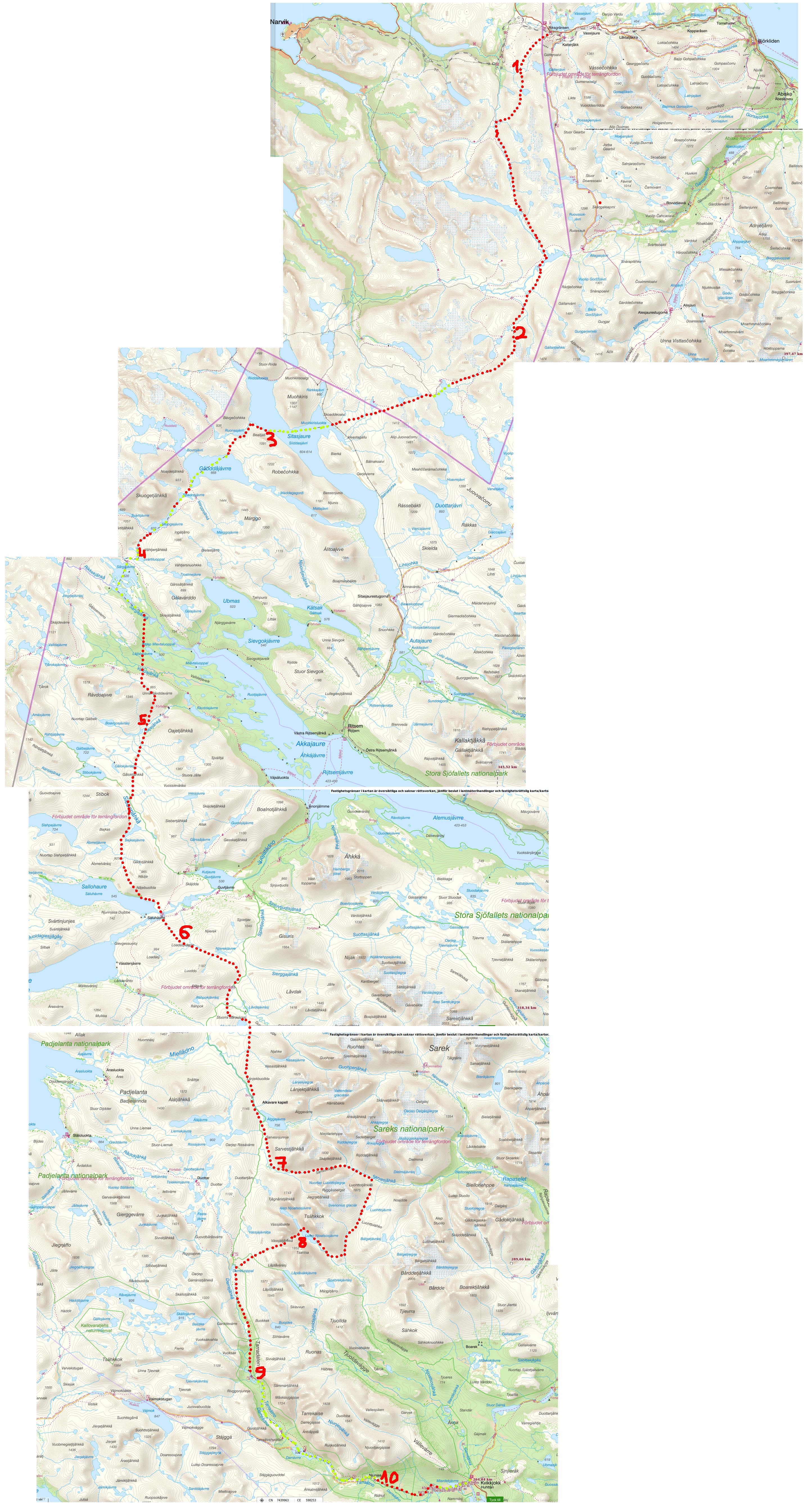
Days 3-4: Sitasjaure to Akkajaure
I had no idea what to expect from this stretch when I was planning the route at home. On the map, it looked like it might be possible to paddle downstream all the way from Kåbtåjaure to the mighty Akkajaure, first south-west along the border on the Swedish side, and then sound-east via Sårgåjavrre. I got as far as crossing Kåbtåjaure with no problems, and the area is both beautiful and clearly unfrequented by tourists. Beyond this point the smart thing is really to follow Nordkalottleden. I tried to paddle, but there are many portages around awesome but at least obvious waterfalls and less awesome, but also rather hairy rapids that are harder to spot in time from the stream. On top of all that, the water level in these creaks was really too low, even for an inflatable boat. I therefore ended up doing about as much walking (with the still-inflated packraft on my head) as paddling until I reached Sårgåjavrre in the morning of Day 5.
The stream that flows from this lake and down to Akkajaure is actually a fine place for kayaking, with roughly class 3 rapids, but I bit off more than I could chew. I first played it safe, repeatedly sighting from the shore (after some minor misadventures on Day 4), but then I got cocky and was swept blindly into increasingly steep drops. My cheap plastic paddle broke as I was struggling to escape from a hole under one such drop, following which I capsized and then had to use all my strength, nerve, and above all sheer luck to rescue myself, my gear, and finally the waterlogged boat from its continuing rodeo in the hole.
In the end I fished out most of the gear, which involved some stimulating white-water swimming. Pretty scary. The gear got wet because on closer inspection the sylnylon waterproof bags turned out not to be waterproof, but luckily it was another sunny day and I managed to partly dry out the essential gear (like the sleeping bag). The boat was undamaged, but the loss of half a paddle meant that I couldn't cross Akkajaure as planned and had to improvise a new route. Worst of all, the hipbelt pocket I was wearing got lost in the current, and with it went my compass, phone (camera / gps), watch, tarp pegs, and other dinkies. I had only the paper map of Sarek left, and I was approximately 25 km north of its northern edge. So the first problem was to navigate south by the sun, over basically unknown terrain, until I was within the scope of my map and recognized some terrain feature that would give me my location.
Days 4-6: Akkajaure to Sarek
Since I was not physically hurt and still had most of my gear and food, I decided not to evacuate but to treat this as a navigation challenge. Therefore, I did not simply follow the stream and then Akkajaure back to civilization, and for the same reason I did not stay on Nordkalottleden when I crossed it next day. Instead, I began by carrying my semi-dried stuff as straight south as I could steer by the sun, aiming for the ridge I could see beyond the woods (Oatetjåkka). Terrible terrain - avoid at all costs! Bushwacking, mosquitoes, and endless swamps with some marshes that I didn't even dare to cross and had to go around. Some streams are so marshy that you have to find a place where they are narrow enough to hop across - the mud seems absolutely bottomless. In comparison, the hills above the tree line are a paradize!
I camped in this paradize feeling that the trip could still be saved despite my foolishness. The morning of Day 6, however, dawned gray and cloudy, meaning that I was left with no sun to steer by (and no compass). Mercifully, there was no fog, and within a few hours I located myself on the map as being in the hills north of Sallohaure. What a relief! Incidentally, this is quite a pleasant area, completely deserted and untouched except for some signs of Saami reindeer herders. In contrast, the low-lying Sallohaure is a nightmare of salix bushes and mosquitoes. I crossed the enormous bridges and was in a hurry to gain as much altitude as possible before camping on the ridge from which I could already see the welcoming peaks of Sarek. Almost home!
On Day 6 I made very rapid progress across easy terrain between Padjelanta and Sarek (between "6" and "7" on the route map). Trails are not relevant here - it's in the sweet alpine zone of altitude between bushes and ragged screes/glaciers (which here is between about 700-800 m and 1000-1100 m). I had enough visibility to not miss my lost compass, and by then my gear had mostly dried, making the backpack pleasantly light again. A curious detail: Alggajavrre is completely infested with mosquitoes (as I also noticed on my previous trip to Sarek in 2015), while just a few km further south I camped with not a single mosquito in sight! Lesson: if the insects are bad, keep going - there's bound to be a better place soon.
Days 7-8: foray into Sarek
From the campsite marked "7" on the map above, the easiest way to reach Kvikkjokk is of course just to head straight south and into Tarradalen. However, by then I was well ahead of schedule and decided to make a detour into Sarek, aiming for the plateau of Luohttolakko that I had visited in 2015 in perfect sunny weather (giving rise to my profile selfie on cogsci.se). Just as I was climbing up the slopes out of the the Sarvesvagge valley, the clouds got thicker and lower, and before long I was smack in the middle of a cloud, with next to no visibility. Without a gps or compass, it was quite a feat to stumble blindly across the plateau and scramble down along a steep creak into the neighboring Njoatsosvagge. Still hoping for better weather, I went northwest and camped on the shore between two spectacular lakes. The clouds were too low to have a good view, but it's certainly a picturesque valley surrounded by high, steep slopes. When the clouds lifted momentarily, the peaks loomed out of nowhere above the fog, as if they were overhanging the lake and couldn't possibly be connected to the ground.
The next day (Day 8) was as rainy and foggy as the previous one, but I was foolhardy enough to attempt to find the pass south of Vassjatjåhkka, or what I now in retrospect call "the Epiphany Pass". I'm sure it's straightforward enough given some visibility or a compass, but I could only see maybe 50 m around me and had no sense of direction beyond the fact that the fog/clouds tended to drift away from the lake and up the slopes. I scrambled up and down the wet screes and snow fields, systematically exploring different directions, stumbling across sheer drops or ending up on increasingly steep slopes until I had to painstakingly retrace my steps and start over again in another direction. After several hours I had finally given up and was heading back down, and at that precise moment the clouds lifted for the first time - just for a minute or two, just long enough to let me glimpse the pass. Without knowing it, I had come within a couple hundred meters of it, but I would never have found it in the fog. I marked the direction and frantically scrambled towards it as the clouds enveloped everything around me again. Within minutes I was there - at the Epiphany Pass.
I was pretty knackered after this stunt, not to mention soaked and a bit shaken. Fortunately, the weather was much nicer south of the pass, and in the afternoon I just walked down a very well-maintained trail along Tarradalen. There wasn't enough water in the stream to use the packraft (plus I only had half a paddle left).
Days 9-10: Tarradalen to Kvikkjokk
This is already pretty civilized, with helicopters flying overhead every few hours, loads of hikers on the trail, lodges every 10 km or so, and other bells and whistles. I did manage to paddle a fairly long stretch, despite the low water level and my very limited maneuverability - with half a paddle, I could basically only float downstream and hope for the best. There are some lethal-looking waterfalls on the stretch after Nunjes. After a portage or two I simply walked on the trail for a few km and then paddled the last calm bit to Kvikkjokk. At this low altitude the valley is overgrown with a fine pine forest, and the Padjelanta trail is actually a very straightforward way to get into Sarek from the west, starting in Kvikkjokk. At high water it can also be a fine place for a two-day paddling adventure (or two days upstream and then two days' paddling back to Kvikkjokk). On foot, I would say it's better to keep to high terrain, following the rocky outcrop of Vallevarre, which reaches almost all the way to Kvikkjokk and which I followed in 2015.
Note on gear for packrafting
With the kind of setup I used, a packraft (+paddle and waterproof bags) adds at least 4 kg to the weight of the backpack. Personally, I wasn't bothered by the extra weight, and the advantages include having fun and alternating between walking and paddling, which gives the muscles a rest and minimizes blisters. I felt that I could do longer days and stay in better shape thanks to alternating between these two types of activity.
If you think about packrafting in purely logistical terms, however, few streams in Scandinavia are long and navigable enough to justify using a packraft as a means of reaching your goal more rapidly. It enables you to follow otherwise unaccessible routes, yes - say, crossing long lakes or fording large rivers - but it doesn't really save time overall. So a packraft can be used in two ways under Scandinavian conditions: (1) you can hike to reach cool white-water stretches and have fun with a sturdy boat (adds 4-5 kg), or (2) you can bring a feather-light packraft merely as a means of crossing lakes, fjörds, and large streams (adds as little as 2 kg).
Don't:
- Underestimate the probability of nasty surprises just around the corner on an unfamiliar stream. Constant vigilance!
- Keep your essential gear in a bag that is not fastened to the boat (in my case, I had my phone AND compass AND watch in a hipbelt pocket loosely connected to the backpack, which got washed away after capsizing).
- Plan to sleep on an inflated packraft. Yes, it feels great when you try it at home, but these boats offer no insulation at all - you'll freeze your backside off on a cold night!
Do:
- Pitch your tarp on the packraft paddle - works like a charm!
- Bring waterproof bags, even if your packraft has internal storage.
- Bring an inflatable seat to protect the floor of the packraft from your bony rear. You could sit on a sturdy waterproof bag or even the backpack, but that exposes the bottom (yours and the boat's) to the rocks underneath.
- Wear a fleece shirt with nothing underneath when paddling. Fleece + rain jacket is as close to neopren as you can get without actually bringing neopren.
- Come with an open mind and have fun! :)))